 Beccles Station Walk
The East Suffolk Railway connected Beccles with Ipswich and opened in 1859, incorporating parts of the earlier Halesworth, Beccles and Haddiscoe, and the Lowestoft and Beccles Railways. The Waveney Valley Railway from Tivetshall on the Ipswich to Norwich mainline reached Beccles in 1863 making the town an important junction on the expanding network. However, by 1966 the Waveney Valley Railway had closed, together with the line to Haddiscoe north across the River Waveney because it had become too expensive to maintain.
Beccles Marsh was given to the people of the town in 1584 by Queen Elizabeth I by granting a charter, now depicted on the Town Sign to commemorate the event. The Town Council, Suffolk Wildlife Trust and the Broads Authority maintain the marsh as a haven for wildlife and have provided waymarked trails of up to 4 miles and this walk incorporates a route all the way around the marsh, although various alternatives are available if preferred.
Walk Route
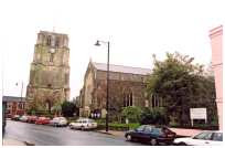 Martyrs Memorial Church in Beccles
From the station walk straight into the town centre along Station Road, Beccles past interesting Victorian houses and the Martyrs Memorial Church where a plaque on the front describes the burning of three men on 21st May 1556 for their beliefs. Continue on across Newgate Street and along Market Street to reach New Market. This area was developed in the 13th century by the Abbot of Bury to cater for growing trade, the quaint little shops stand on the sites of the original 17th century wooden stalls. Turn right along The Walk past the red brick octagonal shaped Town Hall, built in 1765 and standing on the site of the original medieval Market Cross. Continue on to the Tower of St. Michael’s Church, housing a peal of 10 bells and built separately away from the dangerous cliff at the rear of the church. A guide book describing the church is well worth obtaining if you are entering and is available within for £1.50.
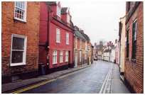 Salt Gate Beccles, end of the Old Market Place
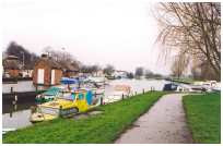
Continue straight on down Salt Gate and past the end of the Old Market Place, probably the original Anglo Saxon site of Fairs and Markets. Walk along Northgate noting several plaques on the walls describing various buildings, including the house of Adrian Bell, writer and father of Martin Bell the former war correspondent. Also note the Scores, access lanes to the staithes or quays on the river where goods of all kinds were loaded and unloaded. Cross Bridge Street and walk on along Fen Lane to reach The Quay. Information about the history of the town, river and the surrounding area is available at the Broads Authority Information Centre to the left. Bear right and cross the water of the yacht station via the footbridge, turning left along the quayside path on the other side. At the end of the Tarmac path turn right along the bank of the River Waveney and under the bridge carrying the A146 Beccles by-pass. Just before passing under the bridge there is a map on the fencing showing a plan of the marshes and the routes of the trails.
Walk on past Beccles Sailing Club where there is a junction of the paths and the point where the red walk turns right off the main walk. Continue along the riverside, now on a grassy path on the bank, following the path for some considerable way until you reach another path junction giving access again to the red walk.
 Beccles riverside embankment
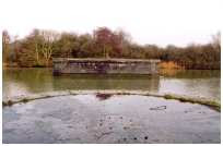
The main walk continues straight on along the riverside embankment. This section of path is also part of the Angles Way, a 77 mile path from Great Yarmouth to Knettishall Heath Country Park following the valleys of the River Waveney and Little Ouse. The next feature you will come across is the pumping station, used to regulate the water level in the dykes of the fen and, a little further on, the site of the old swing bridge that once carried the railway over the river. The railway from Beccles to Great Yarmouth was built across the fen and river in 1854 but proved to be expensive to maintain and was eventually closed in the 1960s, the bed of the track across the marsh is now used for access.
 Beccles riverside marking the eastern boundary of the marsh
The riverside path eventually reaches a yellow topped waymark post at the end of the maintained trail at a right turn down the embankment away from the river. Follow the path as it meanders through the fen and between the trees, following the Worlingham Wall marking the eastern boundary of the marsh separating the Beccles level from Worlingham.
Follow the path at a right turn over a footbridge and then straight on to the right of a dyke, along a willow tree lined track. At the end of a long straight and a junction of tracks turn left and then follow round to the right at the next junction, heading for the farm buildings ahead. At the farm, at a junction of the tracks, turn left past the cattle pens, now walking on the former bed of the old marsh railway through the trees.
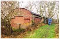 Beccles farm buildings
After passing through a gateway at the pits there is another board with information about the marsh and the trails. Turn right under the height barrier on the grassy track to reach another gate with a stile at the side and leading out to a small car parking area. Walk along the waste site access road and turn right past the allotments to the next bend where the track turns sharply right. There is another Marsh Trail information board here close to the bend.
Turn left on the path alongside the fence and up a few steps to the main A146 road. Cross with care and walk down the steps at the other side past the Fen Lane car park to reach Fen Lane. Turn left and follow Pound Road round the bend to reach the red brick Pound at the junction with Common Lane North. This circular structure was once used to contain stray animals found on the Common and was restored in 1982 by the Town Council and the Beccles Society.
Walk along Common Lane North and right along George Westwood Way to return to the start of the walk at Beccles Station.
Beccles Railway Station is served by National Express East Anglia (Train Operating Company), who operate services between Ipswich and Lowestoft – East Suffolk Line.