 Halesworth Station Walk
Halesworth Station was built in 1859 and, in 1888, was provided with a moveable platform, designed to allow traffic along the main road. This was also once the junction with the Southwold branch line that opened for business in 1879 until it finally closed in 1929. It was also planned to extend the Mid Suffolk Light Railway from Haughley on the Ipswich to Norwich main line to Halesworth on the East Suffolk line. However, construction only ever reached Cratfield near Laxfield and the Middy, as it was known, closed for business in 1952.
Had the railways continued to develop, Halesworth would have been an important junction. Today the station building houses the Halesworth Museum and, together with the moveable platform that was restored in 1999, still provides an attraction for its many visitors. Evidence of the old Southwold Railway can be seen on the walk route.
Walk Route
Walk down Station Road to Quay Street, a road with an interesting mix of houses including Magnolia House on the right that was the home of Sir William Aitken MP. Turn left for about 50 metres along Quay Street and right into the wide access approach to Ridgeons, walking through the steel arch to the path between fences to reach a footbridge over the river.
 This is the site of the original Town Quay, once a bustling area that supported five public houses and many storage areas for the coal, iron, corn, bricks, timber and other goods carried on the river. The first boat arrived from Southwold in 1761, laden with coal and shortening the journey time considerably. However, the river gradually became silted up and the new railway took on most of the transport business in the area with the result that the last boat arrived in 1882.
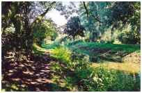
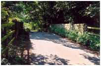
After crossing the footbridge turn left across the grass to the left of a brick wall to walk along the shady path at the edge of the New Cut channel, cut to connect Halesworth with the River Blyth. Continue straight on past the turn over a bridge to The Folly Millennium Green, keeping the water on the left. Where the water flows under the railway pass through a kissing gate into the pasture and then left through another kissing gate, following the path through an arch under the railway.
On the other side cross a footbridge and turn left along the fence and river bank to a bridge marking the site of one of the locks on the canalised river. At the other side turn right along the riverside path, using the numerous stiles and footbridges to eventually reach the road at Mells. At points along this path there are views to the left of the Holton Post Mill on the B1123 road and which was working from 1749 to the early 1900s and restored in the 1960s. It is open to the public on Spring and August Bank Holiday Mondays only, otherwise by appointment although the exterior can be viewed at all reasonable times.
At Mells turn left up the road to cross the old Southwold Railway bridge to reach the Southwold Road.
Turn right along the grass verge to the end of the gravel workings and left on the path through the trees to Blyford Lane, a sandy track. Cross the track and continue up around the quarry edge to a concrete track on the top at other side. Most of the gravel used in the construction of Halesworth airfield came from here and has left an important habitat for wildlife. Turn right along the concrete track to reach the Beccles Road.
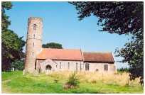 Turn left down the roadside footway and right up the access track and path to St. Peter’s Church. The unique round tower and double roof are reputed to have been used by smugglers who brought their booty up the River Blyth. In the bell tower are three bells dating from between 1498 and 1674 that have not been rung for over 30 years. Turn right on the path in the churchyard towards the housing estate and left between the hedges to reach Lodge Road, named after the lodge of the now demolished Holton Hall. Turn right along the road to reach a Tee junction.
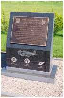
Turn left past the entrance to the turkey factory, standing on the site of the former World War II Halesworth airfield, to reach Gypsy Corner, an old camping place. There are two airfield memorials on the right. The Bomber Group memorial is dedicated to the men of the 489th Bomb Group USAAF who flew from here from April to November 1944, they flew 106 missions in B24 Liberator bombers. On the top of the memorial is diagram showing the original layout of the runways. The Fighter Group memorial is dedicated to the men of Zemke’s Wolfpack 56th Fighter Group, the 61st, 62nd and 63rd Fighter Squadrons, stationed here from 8 July 1943 to 18 April 1944.
 On the bend of the road turn left down the cultivated field edge path, following the hedge down to the Bungay Road. Cross with care to the gate in the railings on the other side and turn right for a few metres before turning left into the hedge lined path known as Lovers Lane. There are many native tree species here, including pollarded oak and hornbeam. The age of the hedges in this old lane have been estimated at 700 – 800 years, found by multiplying the number of species in a 30 metre length by 100 to give rough calculation.
At the top of the path follow the hedge to the right, turning left at the corner of the field and then right through a gap in the hedge to reach Loam Pit Lane, the access track to Town Farm. This was once known as the Pest House where people from the town with contagious diseases were isolated, before a proper hospital was built about 1880.
Turn left down Loam Pit Lane to reach Quay Street, opposite the brick abutment of the former Southwold Railway bridge.
 Turn right under the East Coast Railway bridge, there are several buildings of note in this area, including the converted maltings offices once owned by Sir William Hooker, renowned botanist and the first director of Kew Gardens, and Sir Joseph Dalton Hooker who was the second director of Kew Gardens and a close friend of Charles Darwin.
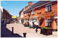
Turn right up Station Road to return to the start of the walk or straight on towards the town to extend your visit for refreshments etc. The name of Halesworth comes from the Saxon Healesuurda meaning Heale’s enclosure or corner of land. A Town Trail leaflet is available describing a short tour of the town and its history, all marked out with information boards and waymarkarrows bearing a duck symbol.
Thank you for taking the time to explore this walk. We would love to hear your comments about this site and about your day out.
Please email us at [email protected]
Source and credits: www.nationalexpresseastanglia.com
Halesworth Railway Station is served by National Express East Anglia (Train Operating Company), who operate services between Ipswich and Lowestoft – East Suffolk Line.